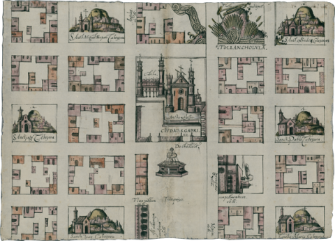
This map (original: 31 x 44 cm.), from 1581 and housed in the Benson Library at the University of Texas, Austin, is an indigenous-authored map that was made in response to questionnaires from the Spanish crown about its colonial possessions. Responses to the questionnaires were called Relaciones Geográficas (RG). The map’s glosses are in Nahuatl and Spanish, and the style is mixed indigenous-European. This is an urban plan of the heart of Cholula, emphasizing a grid pattern, which was of special interest to the colonizers. What are several altepetl (Nahua socio-political units) are encompassed by the map, although they are called “cabezeras” (cabeceras, Spanish for head town) on the map. San Gabriel is the principal church of the many churches shown. The market square, “tianquizco,” holds a prominent, central place. A fountain occupies this space. (Stephanie Wood) ---------- The Benson Library has kindly provided this image for our reproduction of this map in the Mapas Project. Ellen Heenan, at the University of Oregon, has processed the images using PhotoShop and has inserted them into our Filemaker Pro database so that they could be annotated (2015).