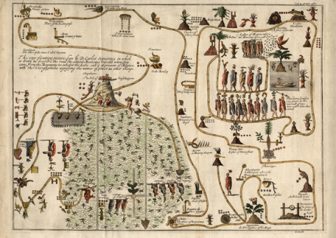
This map-like pictorial manuscript (in a copy from 1704, made by Giovanni Francesco Gemelli Careri, with English translations of its texts, owned by the Libraries, University of Oregon) represents a legendary migration from Aztlan that ended in the founding of Mexico Tenochtitlan (Mexico City). It recounts places on the route and time spent in each place. The original, measuring 54.5 x 77.5 centimeters, now housed in the National Institute of Anthropology and History, was in the hands of historians in Mexico City from at least the seventeenth century onward. It is named after Carlos de Sigüenza y Góngora. Gemelli (1651–1725), a lawyer from Naples, saw the original and made his copy while traveling the world in the 1690s. The publication of his copy, the first publication of the map, appeared in 1704 in A Voyage Round the World. He had other maps that he did not publish at that time, and, after enjoying a period of fame, Gemelli fell from favor. Most of his work was considered fictional. But Alexander von Humboldt brought Gemelli’s work to light again in 1811, believing that Gemelli had a deep geographical knowledge of Mexico. (Brief description by Stephanie Wood based on the map seller’s description, http://www.geographicus.com/P/AntiqueMap/AztecMigration-gemelli-1704, visited in June 2012. See also the copy made in the nineteenth century by Frédéric de Waldeck, called the “Nahuatl glyph map of Aztec migration from Aztlan to Tenochtitlán,” call number Ayer Art Waldeck E1 #21, at the Newberry Library. Here’s a link to a zoomable, digital version of the Waldeck map, http://www.acm.edu/uploads/cms/documents/ayer_art_waldeck_e1_21.pdf)
Sigüenza, Mapa de (Gemelli)
Principal editor:
Stephanie Wood
Provenance:
This map, from the 1704 publication in English, A Voyage Round the World (London), was purchased by the Libraries of the University of Oregon in 2011.
Transcriptions and Translations
| Analytic Transcription | English Translation | Literal Transcription | Spanish Translation | Standardized Transcription | |
|---|---|---|---|---|---|
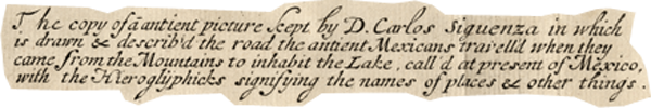 |
[Transcription by Stephanie Wood:] The copy of an ancient picture kept by D. Carlos Siguenza in which is drawn & describ’d the road the ancient Mexicans travell’d when they came from the Mountains to inhabit the Lake call’d at present of Mexico, with the Hieroglyphicks signifying the names of places & other things. | [Transcription of the by Stephanie Wood] The copy of ā antient picture kept by D. Carlos Siguenza in which is drawn & describ’d the road the antient Mexicans travell’d when they came from the Mountains to inhabit the Lake, call’d at present of Mexico, with the Hieroglyphicks signifying the names of places & other things. |