full view, Toluca area
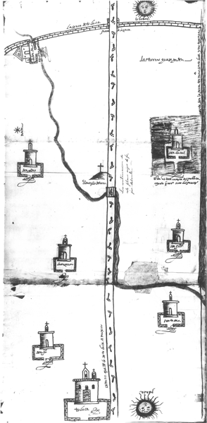
This map shows East at what appears to be the top of the map, and West is at the bottom, where we see a glyph-like symbol for the city of Toluca, with a church and atrium. Six indigenous communities (one now depopulated) are also visible, lying on both sides of the road that heads east from Toluca toward Mexico City. The road has footprints in the style of indigenous maps. This map largely concludes on the eastern side where we see the sixteenth-century wall that once enclosed much of the land in the vicinity of Toluca. The wall is seemingly made of adobe bricks or stone. There is a channel of water flowing along the southern side of the map, and a river winds through much of the area indicated on the map. One purpose of the production of this map seems to have been to indicate some lands that were being sought, whether by the people of Toluca, of one of the indigenous communities, or one of the private holders, such as Agustín Guerrero, who owns an agricultural or stock raising estate near the wall, in the northeast corner of the map. [SW]